Salkantay Trek Distances and Altitudes along the trek to Machu Picchu


Distance and Altitude - Salkantay Trek to Machu Picchu
Click to see larger Salkantay Trek Distances and Altitudes

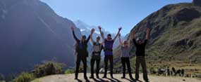
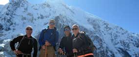
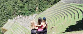
The Salkantay Trek to Machu Picchu passes through stunning landscapes varying from the cloud forest to the high mountains. Along the way you will see the fantastic views of second highest mountain in the Cusco area - Salkantay ("Savage mountain" from Quechua) standing at 20,574' (6,271 m). This trek to Machu Picchu goes through unfrequented areas and combines culture and tradition with the incredible flora and fauna offered by Perú. You will be in the real Andes and the perfect conditions to get a sense of the life in the area.

Salkantay Trek Distances

  • Day 1: Challakancha - Humantay Lake - Soraypampa sky campsite: 13 Km (8.08 miles)
  • Day 2: Soraypampa sky campsite to Collpapampa: 22 Km (13.67 miles)
  • Day 3: Collpapampa to La Playa: 16 Km (9.94 miles)
  • Day 4: La Playa to Aguas Calientes: 19 Km (11.81 miles)
  • Day 5: Aguas Calientes to Machu Picchu: 4 Km (2.49 miles)

Total Distance: 74 Km (45.98 miles)


The standard route on the mountain is the Northeast ridge. Accessing the route typically involves three days of travel from Cusco. The climb involves about 1,800 m (5,900 ft) of vertical gain, on glacier, snow, ice, and some rock.

Salkantay Pass 4600msnm
The Salkantay Pass Altitude is 4600msnm

Day

Altitude

Distance

1 Cusco – Soraypampa
  • Starting Elevation “Mollepata: 2900 meters / 9,515ft
  • Campsite Elevation “Soraypampa: 3850 meters / 12,631ft
  • Considered : Moderate
  • The area : Andes
  • Walking distance: 13 km (approx.)
  • Estimated trekking time: 5 hours
  • Maximum altitude point: 3,850 m (approx.)
2 Soraypampa – Salkantay Pass - Collpapampa
  • Highest Elevation “Salkantay pass”: 4600 meters / 15090 ft
  • Campsite Elevation “Collpapampa”: 3000m / 9842ft
  • Considered: Challenge
  • The area: Andes, Salkantay Glaciar
  • Walking distance 22 km (approx.)
  • Estimated trekking time 9 hours (approx.)
3 Collpapampa – Lucmabamba
  • Starting Elevation “Collpapampa: 3000m / 9842ft
  • Campsite Elevation “Lucmabamba: 2000mt / 6561ft
  • Considered: Moderate
  • The area: Cloud Forest
  • Walking distance: 16 km (approx.)
  • Estimated trekking time: 6 hours
4 Lucmabamba - Hidroelectic - Aguas Calientes
  • Starting Elevation “Lucmabamba: 2000 meters / 6562 ft
  • Hotel Elevation “Aguas Calientes: 2050 meters / 6726 ft
  • Considered: Moderate
  • The area: Cloud Forest
  • Walking Distance: 15km / 9 miles
  • Estimated trekking time: 6 to 7 hours
5 Aguas Calientes – Machu Picchu – Cusco
  • Machupicchu Inca City elevation: 7,972' (2,430 m)
  • Huaynapicchu sacred Mountain elevation: 8,924' (2,720 m)
 

Why Salkantay Trek?

  • We are travel experts.

  • Fully customizable Salkantay Trek.

  • 24/7 support from our experts tours.

Contact Us

Get a 5% discount on all our tours if you make the reservation before of March 31st, 2024

Classic Royal Inca Trail in 4 days
Royal Inca Trail to Machu Picchu in 4 days View Details
Classic Sacred Salkantay Trek 5 days
Classic Sacred Salkantay Trek to Machu Picchu in 5 days View Details
Royal Sacred Inca Trail 2 days
Royal Short Inca Trail to Machu Picchu in 2 days View Details


Please share in